
Heat eases with more rain and storms later this week
- account_circle Tyo Murty
- calendar_month Wednesday, 15 Jul 2026
- visibility 12
- comment 0 comment
- print Print

info Adjust the font size of this article to get the best reading experience.
Extreme Heat Continues to Impact Colorado
The scorching summer heat is still affecting the Grand Junction area in Colorado. An Extreme Heat Warning remains in effect until midnight on Monday night for the Grand Valley and the De Beque to Silt corridor along I-70. Although temperatures are beginning to ease, they are expected to remain in the triple digits on Tuesday and Wednesday before some relief arrives.
Record-Breaking Temperatures Over the Weekend
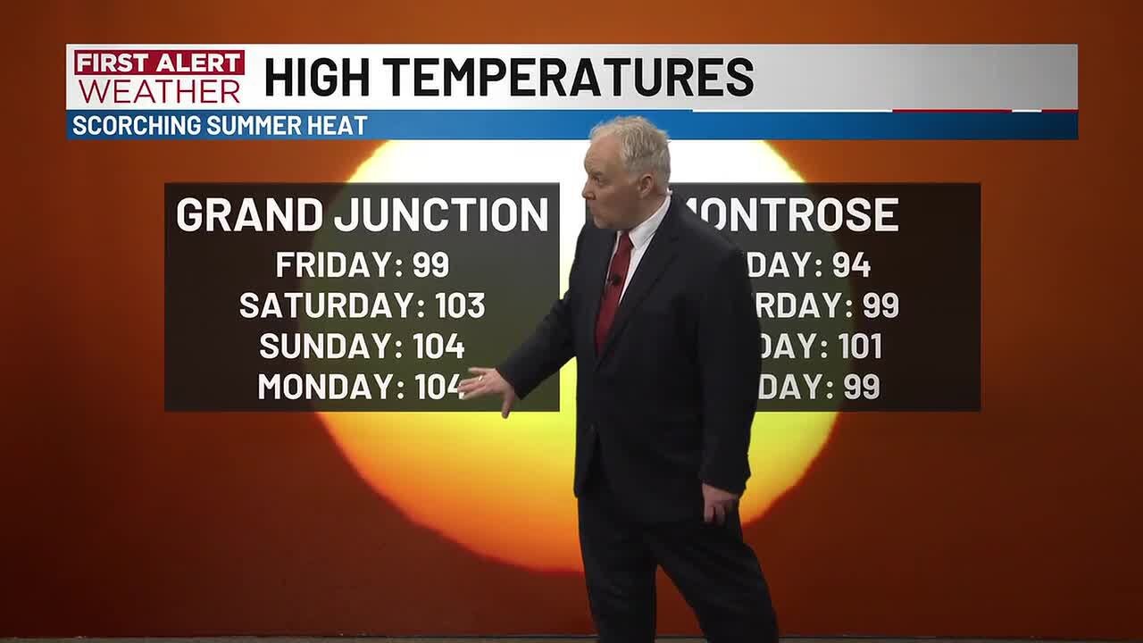
The past weekend saw record-breaking heat across the region. In Grand Junction, temperatures reached 99 degrees on Friday, 103 degrees on Saturday, and an impressive 104 degrees on Sunday. This 104-degree reading on Sunday was the hottest day in Grand Junction in two years. Meanwhile, Montrose experienced high temperatures of 94 degrees on Friday, 99 degrees on Saturday, and 101 degrees on Sunday. The 101-degree temperature on Sunday marked the first time in five years that Montrose has seen a day with 100 degrees or higher. It also tied the all-time record high at Montrose.
Unseasonably Hot Weather Through Wednesday
The forecast continues to show high temperatures in the 90s and lower 100s through Tuesday and Wednesday. The Grand Valley is expected to see the highest temperatures, with around 103 degrees on Tuesday and 100-101 degrees on Wednesday. Delta is likely to be within a degree or two of the Grand Valley’s temperatures. Most other areas will experience highs in the mid-to-upper 90s. Starting on Thursday, cooler temperatures in the mid-to-upper 90s are expected. There is also a chance of scattered showers and thunderstorms, though these may not provide significant relief to all areas. Increased humidity will also make swamp coolers less effective.
Air Quality Health Alert Remains in Effect
An Air Quality Health Advisory is still in place for Montrose and Ouray counties through at least 9 AM on Tuesday. This alert could be extended if the Gold Mountain Fire continues to produce large amounts of smoke, which can negatively impact air quality.
Detailed Forecast for Tuesday
Tuesday will start off sunny and warm, with a gradual increase in cloud cover later in the day. Temperatures will rise from low-to-mid 70s at 7 AM to low-to-mid 90s by noon. By 4 PM, temperatures are expected to reach high 90s and lower 100s. High temperatures in the afternoon will be near 103 degrees around Grand Junction, 97 degrees around Montrose, 102 degrees around Delta, 94 degrees around Cortez, and 103 degrees around Moab. Morning low temperatures will be near 73 degrees around Grand Junction, 65 degrees around Montrose, 67 degrees around Delta, 57 degrees around Cortez, and 75 degrees around Moab.
- Author: Tyo Murty

















At the moment there is no comment